
Day 26 (Apr. 19): The big question for today’s hike is how much snow/ice is on the PCT by Mount Baden-Powell – there is a lower alternate PCT route hikers can use when Baden-Powell has high snow – but on-trail info about snow conditions is usually sketchy and contradictory. So my big hope for the day is to get accurate info about the snow conditions.
Early in the day, I hike a bit with Rainbow, and we crossed a few stretches of trail covered with snow together, until I elected to stop to put on microspikes for a longer stretch with a fairly steep slope below the trail. How embarrassing would it be to slide down a mountain with microspikes in your pack instead of on your feet?
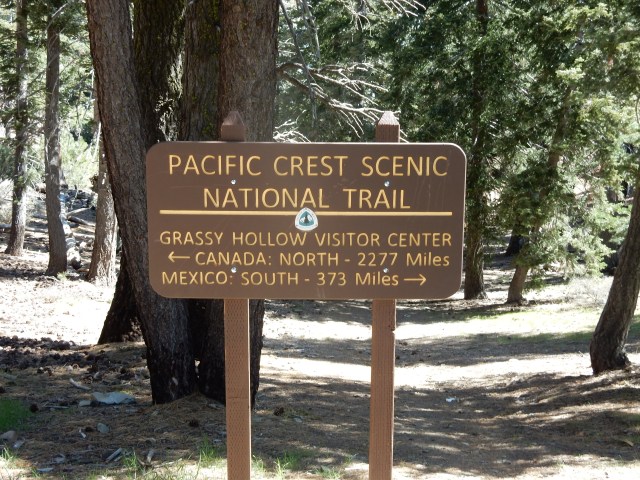
An important water source for today is something called Grassy Hollow Visitor Center, which is locked up tight, and I semi-freak our when I see signs on the Center that say the bathrooms are closed “due to a water outage” (and the adjacent water fountain is indeed shut off), but it turns out there is water from a spigot near a campsite, so I have water for the morning, even if it does turn more and more yellow as the hours go by… Once again, I trust in the 0.1 absolute micron Sawyer water filter to keep me safe from suspect water. Grassy Hollow does have one of my favorite kinds of signs, reporting the distance to Mexico and Canada.
This section of the PCT also includes a longstanding “Official Endangered Species Detour” to protect the highly-endangered Mountain Yellow-Legged Frog, “once the most abundant amphibian in the Sierra Nevada and Transverse Ranges of Southern California.” I’m happy to walk a detour for this species, and I hope the U.S. Fish and Wildlife Service will finally develop the required recovery plan for this endemic species.
The morning includes a hike right next to the Mountain High ski resort, with its “Inferno Ridge” and “Conquest” ski runs.

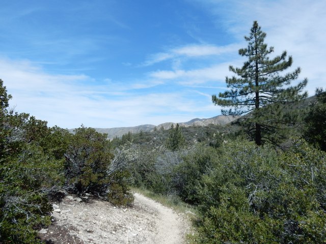
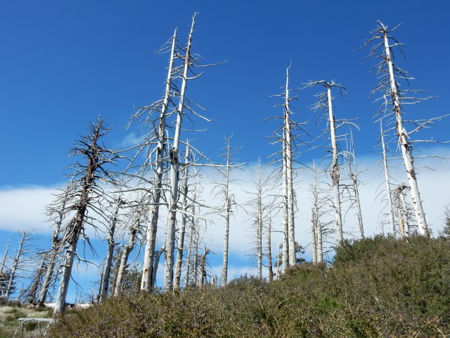
Views are terrific as I hiked toward Baden-Powell:

I had an enormous stroke of luck when I reached Vincent Gap, the point where you make the choice to continue upward to Mount Baden-Powell or take the High Desert Trail Alternate (the Manzanita Trail) to bypass Baden-Powell during high snows. Vincent Gap is on Hwy 2, and in addition to a small parking lot, it has a few “amenities” – an outhouse, trash cans, and a bench. On the bench sat a hiker drinking a Coke, and meeting him was my stroke of luck.

Woody, at a little stream that was one of our water sources for the day.
I walked over to the hiker and my first question was, “Where did you get that Coke?” I don’t even drink Cokes, but it was such a luxury item I had to ask. Thus, I met “Woody” (James C.), who sends himself Cokes in his resupply boxes, and was drinking one from his Wrightwood resupply. As it turns out, Woody had just summited Mount Baden-Powell, but beyond that point, he found it impossible to navigate the PCT because the trail was buried in snow, so he had hiked all the way back down to Vincent Gap and was going to take the lower trail. He reported that “Team Emerson” – a mother and her 9-year-old son – had also hiked back down, unable to continue past the summit. That was just the fresh intel I needed to make my own decision, so after I lightened my pack by putting my accumulated trash in the trash cans, Woody and I started hiking the alternate trail together.
Woody pinpointed where I was from just by hearing traces of a regional accent as I spoke, and unbelievably, we soon discovered we had been born in the same hospital and went to the same elementary and high schools. I was about 5 years older so we weren’t in the same classes, but his step-sister was in my class and a close friend of my sister’s. So we hiked together reminiscing about childhood places and landmarks – Underwood BBQ, Furr’s Cafeteria, drive-in movies, bowling alleys, etc.
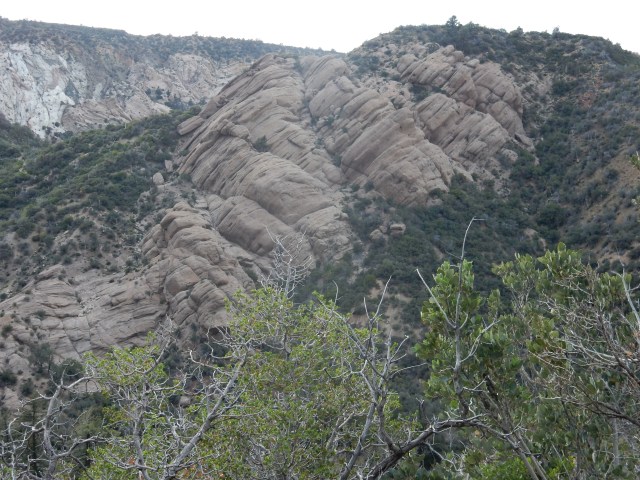
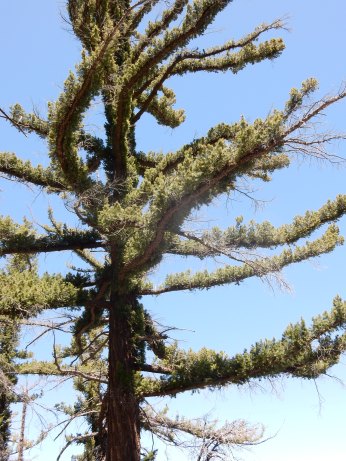
Woody and I enjoyed the Manzanita Trail and part of the Official Endangered Species Detour together, with interesting tilted layers of sedimentary rock:
We camped together beside Holcomb Canyon Creek – after the limited water sources in recent days, it was a joy to camp beside a creek with abundant rushing water. The campsite had some strange items: a huge bedroll tied up in a decaying blue tarp, a rough-hewn bench made from branches, and other things that made us speculate about their source and possible illegal activities associated with them – but like many odd compounds you see in isolated areas near the trail, it is impossible to know the stories of most of these sightings.
Today’s mileage: 17.7 miles, including 9.5 miles from PT 364.5 to 374; 5.8 miles of the Manzanita Alternate (to South Fork Campground); and 2.4 miles of the Official Endangered Species Detour (Mile 5.3 to 7.7, Holcomb Canyon Creek).
Day 27 (Apr. 20): Woody and I continued on the Official Endangered Species Detour, with me hiking all morning under a chrome umbrella for sun protection and the ability to let the breeze reach my head and hair without hat interference.

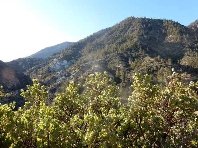
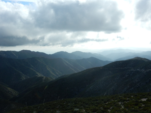
We had big views with lots of variety:
And we opted out of a side trip to something called “Devil’s Chair.”

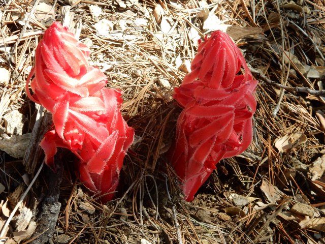
We saw some beautiful Snow Plant (Sarcodes sanguinea), an entirely red, snow-following, non-synthesizing plant that lives based on a symbiotic relationship with underground fungi. So just because you see a plant without green photosynthesizing elements doesn’t mean it’s a parasite – it could be involved in a mutually beneficial cross-species relationship!
 I see Beast and Forget-Me-Not (the two New England women who are 21 and 24 years old and who hiked the Appalachian Trail in 2014) at a water source where we all get water. I hike alone, ahead of Woody, for part of the afternoon. At last, I finish the Endangered Species Detour and re-join the PCT near a beautiful creek (at right).
At the creek, I finally meet the hiker known as Prince, who has been hiking close to Beast and FMN recently. Prince’s trail name comes from the fact that he carries a ukelele and performs a beautiful version of “Purple Rain,” along with a host of other songs. Until recently, he was in the Air Force Band, and his diverse repertoire and evening serenades will become a treasured part of my hike in the coming weeks.
The evening finds us all camping together at Cooper Canyon Trail Camp, a creek-side campground that has a pit toilet and picnic tables. It’s quite a festive group, with Beast, Forget-Me-Not, Prince, Woody, and me -a virtual party! We cook or assemble our dinners on a picnic table, then Prince and I have some hilarious moments reviewing a list of words that Beast and FMN don’t know, compiled while reading a book together on trail. Prince and I try to define as many of the words as possible. I double over laughing when I see the word “priapic” and defer to Prince to explain it to them. Prince tackles “tautology” with the example, “It is what it is,” which is a very useful concept for thru-hikers.
Today’s mileage: 13.9 miles, including 12.8 miles of the Endangered Species Detour (Holcomb Canyon to Burkhart Trail junction at PCT Mile 394.1), then 1.1 PCT miles to 395.2.
Day 28 (Apr. 21): The 400 Mile Marker + Return of the Monster Winds!
 Today’s hike found us hitting the 400 mile mark early in the morning – a milestone suitably commemorated in rocks by the side of the trail. I hiked alone, but really enjoyed knowing that trail friends were relatively close, either ahead or behind me.
In this stretch, we’re still calculating our water sources carefully, making sure to carry enough to get us to the next reliable source. At a camp named Camp Glenwood, the tap from the water tank isn’t on yet, but there is a box of trail magic – fresh apples and oranges left by the staff of the Angeles Crest Christian Camp. Sparks, Rainbow and I enjoy some fresh fruit and I leave a thank you note on the box with my mini-Sharpie. Words really are inadequate to convey how amazing a fresh orange tastes on trail. Thanks, camp staff!
Some of our views today:
Once again, we’re walking through some significant fire burn areas.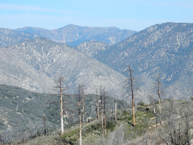
 And since we’re in a fire burn area, we start to see the native fire-follower, the infamous poodle dog bush (Eriodictyon parryi, formerly Turricula parryi). It’s infamous because it is highly allergenic to many people, causing a severe contact dermatitis. If you can get past that negative quality, in full flower, it can be one of Southern California’s most specctacular flowering plants, but most people can’t get that far past the negative.
At some point, I pass by a dirt road where a PCTA trail maintenance volunteer (named John, if I recall correctly) asked if I needed water, and told me he would be working the following day to take out some of the blow-downs – large fire-damaged trees that have blown down across the trail. I’m so grateful for his work, because some of these blow-downs can be really difficult to cross, and I’ve encountered many on the trail so far.
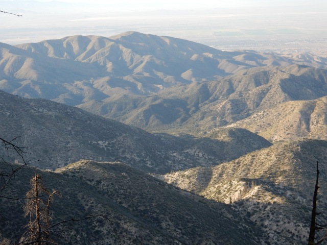
I know that some of my fellow hikers are planning to get to Mile 415 today, which is the last good place to camp before a long descent down the mountain, so I hike on through some diverse and beautiful landscapes hoping to join them for the night:

Once I get to Mile 415, I find Rainbow, Sparks and Prince with their tents already set up, and a pretty big wind whipping around our exposed site. Prince thinks the wind will die down, and I set up my tent nearby. The views at dusk are stellar:

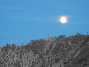 The moon is full, and for awhile, Prince sings and plays his ukelele, until he announces that his fingers are too cold to continue. He says he thinks the wind will die down, but in fact, it just increases in intensity during the night.
Around midnight, Rainbow decides there will be no sleep in these winds, so he packs up his tent (no mean feat in the high winds) and night-hikes down the mountain.
At some point, Sparks’ tent collapses on him, and he doesn’t even try to set it back up. A guyline on Prince’s tent snaps, breaking a stake.
I lie in my tent, with monster winds bending and flexing the poles that form a frame for my tent. I wonder how much wind it would take to take my tent aloft, with me an involuntary parasailer. My amazing 2-lb.LL Bean tent handles the monster winds with no problem – WOW! – though sleep can’t override my wide-eyed fear as I listen to the howling winds and watch the tent poles bend and flex, bend and flex. Once again, I find myself sending up a huge thanks to my LLBean friends who have provided me with the most critically important gear for my wildest moments on the trail.
Today’s mileage: 19.8 miles, PCT Miles 395.2 to 415.
Day 29 (Apr. 22): By 5am, we are all packing up rapidly in the still-strong winds, and using the earliest light to start down the mountain. I’m at a near-running pace, on the theory that lower will mean more protection from the wind, and so I race through some interesting landscapes, many featuring the Angeles Crest or Angeles Forest Road below:

 There are some big fire areas and challenging blow-downs today, including some that require some intricate dance-steps to both get over/under a huge tree trunk and not end up right on a lovely specimen of poodle-dog bush.

In the midst of the harshness, there continue to be beautiful flowers and fantastic living trees.
 We also see abundant evidence – in the trail work that has ameliorated the impact of many blow-downs, done by incredible volunteers like John, and in the trail sign left by Trail Angel Mary (at left) – that many folks are dedicated to taking care of the PCT and the hikers who enjoy it. I think about all of these volunteers: people who drive and hike long distances to build and maintain the trail; people who are willing to host hikers in their homes, or drive them to the doctor, the local gear shop or grocery store, or get them to remote trailheads – and all I can say is that it is a humbling thing to contemplate all of these volunteers whose work, seen or unseen, known or unknown, makes hiking this amazing trail possible.
Just 3.63 miles into the morning’s hike, I reach the Mill Creek Fire Station, which has a small rest area nearby with a water spigot, picnic table with a trail register in a metal box, and a pit toilet (with toilet paper! Truly a 4-star trail amenity!). There, I find John, the PCTA trail maintenance volunteer, ready to meet his fellow volunteer and start work on some blow-downs. I share with him my observations about the worst blow-downs I’ve just passed, and am grateful that he and his one-person crew will be making the trail better for the hikers just behind me.
Prince hikes in and says he needs to go off-trail for a day or so because of a sore ankle, and needs to find out how he can get off-trail. “Call Trail Angel Mary,” I say, but he has no idea what that means. It turns out that Prince entirely missed seeing Mary’s lovely sign offering assistance that was right on trail, so I show him my photo of it, and he indeed ends up getting off-trail later that day with Mary’s assistance. (I encountered him again a day or so later at the Acton KOA, where he was taking some time to allow his ankle to recover).
The views continue to be interesting, as I hike toward the North Fork Ranger Station:
 At one point, I cross a dirt road and start walking up the trail as it curves up and around a ridge. Instantly, I’m whacked by powerful winds that make it almost impossible to stand up. The winds are blowing me into the mountain, so even if I can barely stand, at least I’m not in danger of being blown OFF the mountain. Surely, if I can just get around the bend, I’ll be more sheltered. So I walk like a drunken sailor around the curve of the mountain, and make it by late afternoon to the North Fork Ranger Station.
Once there, I walk around to check out the water cache, though I don’t need water, and take advantage of the one other amenity: a pit toilet with toiilet paper! What an amazing, amenity-filled day it has been, with not one but TWO pit toilets! I’m about to continue up the trail when a ranger comes over to greet me, along with a section hiker named Shaggy, to let me know that because of the high winds, he is allowing hikers to shelter behind the ranger building tonight. So I set up my tent behind the building, and meet Team Emerson for the first time (the woman who is hiking with her 9-year-old son Emerson, often called Boone because he wears a cap with a coontail).
Emerson and I have a hilarious first conversation. He peers at me from his tent, which is fairly far from me, and says: “Say, is that a WART on your nose?” Wow, I had no idea the ding in my nose was so prominent, from the basal cell carcinoma removal that took place the day before I started my hike. I reply, “No, that’s where I had a cancer removed from my nose the day before I started hiking the PCT.” Emerson screeched, “CANCER!!!” and I realized I was talking to a 9 year old, so I said, “Oh, it wasn’t a serious kind of cancer; nothing to worry about.” This conversation makes me glad I haven’t been around a mirror for the past month.
I warn my neighbors that I’ll be packing up and hiking out early, because tomorrow morning, I want to get to Acton KOA by 9am, where I’ll find Dwight and Molly – they will have just 2/3rds of a day to spend with me while I put together my resupply from the buckets of hiker food and gear that Dwight will bring. So tomorrow, I have a real schedule to keep, and I’m highly motivated to get going early.
Today’s mileage: 21.08 miles (PCT Mile 415 to 436.08).

Wow! Betty, you are truly amazing! You are a determined and extremely fit woman and you have my undying respect! i was very proud of myself for hiking 6 or 7 miles a day in China in what I thought was difficult terrain, but reading your blog makes me feel like such a wimp. I stand in admiration of you and resolve to do better! You are an inspiration.
LikeLike
The thought of you as a wimp is laughable, Martha! I’m a big admirer of your strength and determination.
LikeLike
I agree with martha. Only my big feat was to climb up Cadillac Mountain with phil and two wiener dogs. Took maybe three hours! Man, it was rough going.
LikeLiked by 1 person
Looking forward to seeing and hearing all about this adventure Monday, October 24th!
LikeLiked by 1 person
Love your writing and the chronicle of your excellent adventure! Great pics too, thanks!
LikeLiked by 1 person
You are amazing Betty! I have to ask how is Molly doing without seeing you every day? I am sure you miss Molly and Dwight but what an adventure you are having.
Of course always having standard poodles in my life has me interested in the poodle plant:~). Would you have any photos of the plant in bloom? I would love to see photos of it some day. Enjoy every second!
LikeLike
Molly sometimes gives me the cold shoulder for awhile when she sees me at resupply visits, but I think she’s starting to get the routine. As I go farther north, though, I’ll see her less, so it’s definitely one of the few “negatives” of my hike. She and Dwight spend tons of time together, so that’s great for her.
I may have photos of poodle-dog bush in bloom to post later, but meanwhile, you can see a beautiful one here:
http://www.photographyontherun.com/prun.asp?id=1043
and a few more here: http://www.fs.usda.gov/detail/angeles/recreation/?cid=stelprdb5318308
LikeLike
Betty, I was wondering if I could re-post some of your photos and journal entries on the http://www.pcttrailsidereader.com website? I remember posting a story you wrote about doing trail work up in the Goat Rocks nearly three years ago. I appreciate the detail of your journal and attention to the quality of the storytelling. Makes for good reading. I will always give you credit and link to your blog. Let me know if this is OK.
LikeLike
Hi, Rees: Yes, you’re welcome to re-post, as long as there is a link back to the relevant original blog post. I remember the nice job you did with the Goat Rocks trail work story (and I have a link to it in the “breadcrumbs” list on the right-hand side of this website). I’m a big fan of the PCT Trailside Reader – thanks for the great work you folks do to publish it!
LikeLike
Thanks, Betty. I’ll make the first post on June 1st. I look forward to continuing to follow your journey north.
LikeLike
Wow! After reading this I am reminded of how important your friendliness is to acquire good trail intel. And the incredible importance of trail angels. Fabulous postings, Betty, I just love them! Thank you! Now Barley and I are off to a “mutually beneficial cross-species relationship” outing of our own at dog park! I will call Dwight to see if I can pick up Molly.Can’t wait to hear more!
LikeLiked by 1 person
Hi Betty! Great post. Interesting you found someone from your home town on the trail, Woody. Good job surviving the harsh winds out there. Your photos are great – the snow bloom flower-thingy is very beautiful and alien-looking. Lastly, the sign with the mileage to Mexico and Canada really puts it in perspective how far you have come already!
LikeLike
Thanks, Laurel. Woody is carrying a toy version of the cartoon character Woody on the trail, and I only wish I had a copy of the photo he took of cartoon Woody standing by the Snow Plant – it’s hilarious!
LikeLike
p.s. a new friend of mine – Trish – from work is also an avid long-distance backpacker. I’ve given her the link to your blog as she is interested in following your journey as well.
LikeLiked by 1 person
You are an amazing flower person. Thanks for introducing me to Snow Plant, how exotic! Extraordinary the coincidence with meeting Woody.
LikeLike